The LOSG
Working on Solutions for our Community
Modeling is a predictive tool with significant levels or inherent uncertainty. As a result, modeling should be used only to point the way toward mitigation programs and other Basin management actions that could potentially protect and restore the Basin. Sustainable Ground Water Management Action (SGMA) and Best Management Practices (BMCs) do not recognize modeling as a basis for determining a basin’s sustainability. Reliable well-monitoring data over time must be used to determine whether planning actions are successful and the Basin provides an adequate long-term water supply for current and any sustainable future population.
(Also see Letters--Los Osos Community Plan/New Development related, which further explain problems with monitoring and some of the ways that Basin modeling is likely to be overstating actual sustainable yields.)
See our October 1, 2020 letter to the Coastal Commission
See our five letters to the Planning Commission between 2015 and August of 2020 posted in “Letters--Los Osos Community Plan/New Development related")
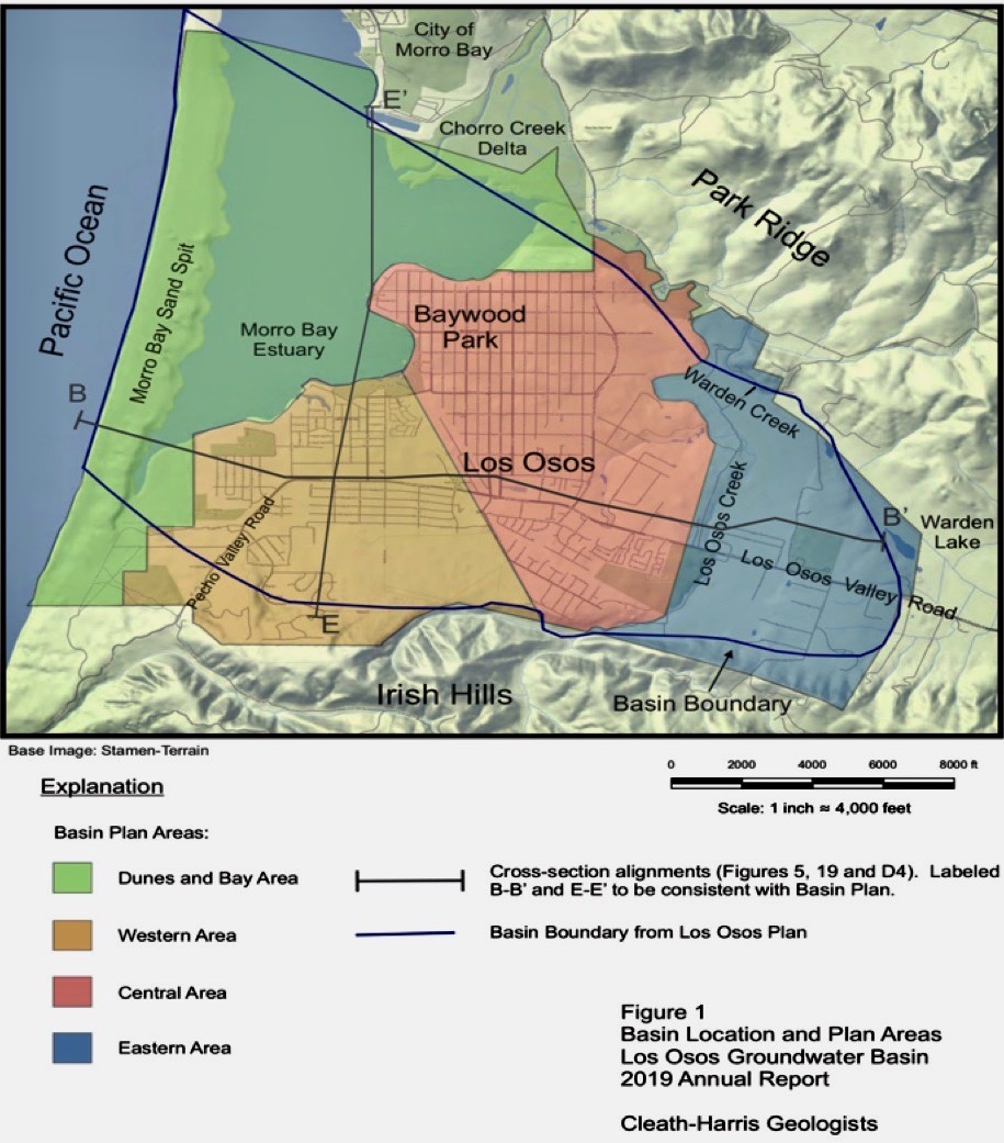
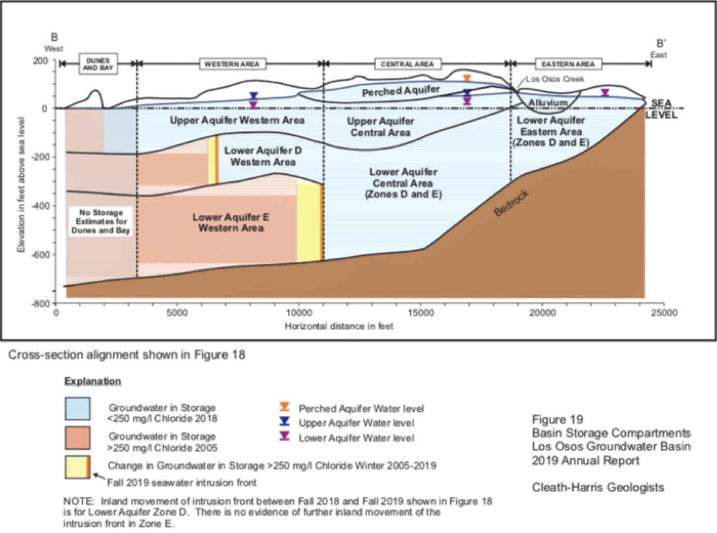
Water levels throughout most of the lower aquifers (Zones D and E) in the urban Basin (Western and Central Areas, extending from the edge of the estuary to near Los Osos Creek are near or below mean sea level for at least part of the year. Some areas are 20’ of more below mean sea level for part of the year. These very low water levels make much of the Basin vulnerable to seawater intrusion. Despite the importance of tracking conditions in all parts of the Basin, the entire northern portion of the urban Basin, an area of at least 1000 acres, has only four lower aquifer monitoring sites, and other parts of the lower aquifers have significant gaps in sites. Because the Basin is relatively small coastal Basin, we have the opportunity to install enough monitoring wells to know the exact positions of seawater intrusion fronts and water levels throughout the Basin, as wells as the responses of the Basin to management actions, climate change effects, and other impacts. More monitoring sights can take much of the guesswork out of Basin management allowing saving time, money, and possibly the Basin.
Value of a Sustainable Basin
Basin Sustainability
As the sole water source of the Los Osos Community and area farms, the Los Osos Groundwater Basin is essential to the social and economic health and sustainability of the community and area farms. It is also essential to the health and sustainability of environmental resources, including groundwater-dependent environmentally sensitive habitat along Morro Bay National Estuary and along Willow and Los Osos Creeks, which border the community to the east. A healthy and resilient Basin would support the area without costly and increasingly unreliable imported water and other supplemental water, such as desalination, for many years into the future.
overuse and potential destruction of the Basin we describe above.
General Sustainability Goal for the Basin
Our general sustainability goal is for the Basin to be restored to a healthy and resilient water source with no seawater intrusion under the community inland of the estuary and freshwater levels high-enough above mean sea level in all its aquifers and parts to sustain the community, area farms, and environmentally sensitive habitat indefinitely, including through long-term droughts and the impacts of climate change (sea level rise, less rainfall, and higher temperatures).
Click here for more on our Goals focused on Basin Sustainability. to understand the rationale for the 4 main goals of the LOSG relating to long term sustainable basin management, sensible land use policies that address the corcerns of both the home owners and business owners, increased community involvement, and community empowerment throught awareness.
Click here for a brief history of the LOSG's efforts to protect the Basin.
Measureable Sustainability Objectives for the Basin (To be announced.)
We are currently formulating and may modify the objectives we provide below as we research and receive further information. Currently, we support the retreat of the seawater fronts in Zones D and E as shown by sufficient reliable well-monitoring data (chloride concentrations) to conclusively establish that seawater front positions have retreated to locations targeted by the Basin model with Basin-wide pumping at or below the Yield Metric Target of 80 (i.e., pumping levels at or below 80 percent of modeled “sustainable yield.”). These locations are near the estuary shoreline on the southwestern edge of the community and under estuary further northward. The water levels we currently support for lower aquifer Zones D and E are 8.5’ and 12’ above mean sea level (msl) respectively throughout the Basin. The Basin Plan currently sets 8’ above msl as the target for the Water Level Metric, but it indicates that water levels inland would be 8.5’ to offset lower levels in wells on the sandspit. The Basin Plan also points out that water levels must be 9’ and 17’ above msl respectively in Zones D and E in the deepest parts of the aquifers to hold back seawater intrusion, which is one reason we may modify our position.
Position on development
We support well-planned development (“smart growth”) that has a verifiable adequate water supply to sustainably support that development indefinitely. For the Basin to provide a sustainable water supply for additional development, the Basin must first be shown to be a sustainable water supply for current development and population. This requires sufficient reliable well-monitoring data to conclusively show that water levels in each of the main aquifers (Zones C, D, & E) have been raised and can be maintained, long-term to reverse seawater intrusion fronts to prescribed locations offshore of the community through droughts and climate change. The levels must also provide groundwater flows to habitat along the National Estuary and area creeks.
Protecting against droughts and climate change requires raising water levels in each aquifer to above the levels needed to reverse seawater intrusion with a margin of safety (water in storage) that will support a given population during long-term through droughts and other unforeseen events, such as worse-than-expected impacts from climate change, earthquakes, and/or inaccuracies in modeling that result in inadequate mitigation programs.
If sufficient reliable data shows long-term sustainable conditions for the present development have been exceeded, some level of added development should be sustainable.
What it will take to stop seawater intrusion and restore the Basin.
The community has already reduced water use through conservation considerably allowing reduced pumping in purveyor Zone D wells and the one Zone D-E well inland of the estuary. However, seawater intrusion into Zone E continues, and seawater intrusion into Zone D, which showed signs of improving in 2017 and 2018, showed signs of worsening in 2019.
The Basin Plan and Annual Monitoring Reports propose additional conservation and shifts in pumping to the upper aquifer and inland to further reduce pumping from wells nearest the estuary (about one to two miles inland). However, it remains to be seen whether this will be enough to stop and reverse seawater intrusion.
The need for more monitoring wells
Position on monitoring vs. modeling
Consequences of unsustainable development
Further development over the Basin will create an irreversible higher level of demand than would happen if the current population reduced water use as much as possible with the voluntary conservation program put in effect by the County and Basin Management Committee. A higher level of demand will result with new development even if that development is required to meet a 2:1 retrofit offset under Title 19, as currently required by the County, because retrofitting the same number of existing homes and businesses through a program for the existing population would produce twice as much water savings and seawater intrusion mitigation benefit.
If the higher demand from new development is found to exceed a true sustainable yield of the Basin, the overdraft could lead to loss of the irreplaceable water source. The Basin Plan points out that when demand exceeds sustainable yield, the adverse impacts may not be known for “as long as 15 years,” by which time it is too late to reverse the harm done to the Basin (Basin Plan, p. 135). Thus, unsustainable demand must be avoided because too much Basin capacity has been lost to seawater intrusion already and raising water low water levels in the Basin to stop seawater intrusion will already be very difficult d.ue to lower average rainfall over 15 years.
The Basin is threatened, not only by seawater intrusion and low water levels, but also by the considerable development pressures that have been building over more than 30 years of a Water Board-imposed building moratorium. Now that the Los Osos Water Recycling Facility (LOWRF) is operational, expectations are high that building can proceed in Los Osos. Housing shortages in the state and region also contribute to development pressures.
However, without a precautionary approach and adherence to policies and standards that avoid unsustainable growth, the considerable investment of current homeowners, business owners, and other stakeholders in Basin sustainability could be lost, along with an irreplaceable and invaluable resource.
Economic Sustainability
Several studies and reviews of water options for Los Osos have concluded that restoring the Basin is the most cost-effective way to provide adequate water for the community. Adding development in Los Osos may, at first, seem like a good way to reduce water and wastewater costs for current home and business owners—by spreading the costs of the LOWWP and Basin programs to more users. However, the cost of supplemental water, if needed, could easily exceed any reductions in homeowner costs.
Funding enough supplemental water to supply just a fraction of what the Basin now provides, requires an investment of tens of millions, even hundreds of millions of dollars. The infrastructure needed would take many years to build, and the water if imported may still be unreliable and will likely go up in cost. Desalination is energy intensive and expensive to operate and maintain, and the environmental obstacles, e.g., for brine disposal, may be insurmountable.
On the other hand, maintaining the economic viability of the community, given the need for additional Basin Plan programs to stop seawater intrusion and restore Basin water levels, will require careful allocation of costs to ease the burden on existing business and homeowners.
If, at any some point, sufficient reliable well-data conclusively show that Basin Plan programs, including improvements, are not adequate for the Basin to sustainably support the current and some level of future population, we would support supplemental water. Until then it should not be pursued because of the vicious cycle of overuse and potential destruction of the Basin we describe above.
Position on the Los Osos Community Plan